


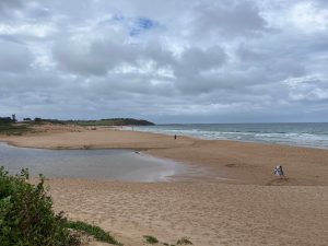
Dee Why area has long provided information on coastal change in the Sydney region. It all started for me as an undergraduate reading the inspirational study of rip currents by Peter Mckenzie in the Journal of Geology (1958, vol. 66, 303-133). I took a class of school students to the Long Reef end in 1961 to exam a peat outcrop at the back of the beach.
One of the first radiocarbon dates in coastal NSW came from peat at this site ( LJ-451 c.3980 C14 years). Drilling, sampling and dating variously involving Tony Martin, Russell Blong, Angus Gordon and me, established the stratigraphy and age of deposits including on a Eucalyptus tree stump located just above high water mark (I-8153 c.6010 C14 years (Martin, A., 1971, “The depositional environment of the organic deposits on the foreshore at north Dee Why, NSW”, Proc. Linnean Soc. NSW, vol. 96, 278-281; Gordon, A. and Cooke, R., 1977, PWD Report 77029; Thom, B., 1984, “Transgressive and regressive stratigraphies of coastal sand barriers in southeast Australia”, Marine Geology, vol. 59, 137-158). Plate II in the 1984 paper shows the peat outcrop in 1961, and Fig. 2 depicts the stratigraphic sequence of a typical “receded” barrier formed with sea level around its present position.
Perusing my literature stratigraphy this summer, I dug into a forgotten file on Dee Why given to me years ago by Russell Blong of Macquarie University. Besides information on his sampling and dating it contained a large folio of the proceedings of the NSW Supreme Court case between James Leslie Wheeler and William Booth (No. 2851 of 1908). Wheeler, the plaintiff, represented the Registrar-General of NSW while Booth, the respondent, the Salvation Army. These proceedings provided a mine of information on the coast as understood by professional and community interests, including recognition of the peat outcrop. It illuminated me on just how powerful land interests, here the Salvation Army, demanded the right to prevent public access to both the lagoon and beach. Further digging drew me to recent articles in the Manly Daily (9 March 2025) and the Dee Why News (11 May 2025) both touching on the fight to save Dee Why Lagoon. Old photos of the lagoon and sand barrier in the Manly Daily article are worth viewing.
What this case represented was another example of how land grants in the early 19th century were used to deny the Crown of lands and waters that should be in the public domain. Caroline Ford has discussed this general issue in her book (C. Ford, 2014, Sydney Beaches—a History, UNSW Press). At Long Reef, William Cossar was granted 500 acres in 1819 and in 1821 sought a further 200 acres covering what was then known as DY Lagoon. Successive land owners led to one (Elizabeth Jenkins) bequeathing in 1900 a broad area totaling 1740 acres to the Salvation Army. The Salvos used wire netting to prevent access. They regarded the lagoon as their land because it was a “lake” surrounded on all sides by their property including the beach “spit” or sand bar. Public deputations were made in the early 1900s prompting legal action by the NSW Government to declare the lagoon and the sand bar Crown Land.
The case before Justice Street in 1908 had two related questions: first was the lagoon an arm of the sea or an inland lake; and two, whether the spit across the entrance to the lagoon was accreted and hence allowed land and lagoon to be claimed as private. Lawyers for Booth placed evidence before the court that more often than not the entrance was closed. This meant that under English common law the lagoon was a “lake” owned by the Salvos. Several witnesses testified in support of this position including Acting Professor Woolnough, Geology, Sydney University. He stated that “In a scientific sense it (the lagoon) has not been an inlet of the sea within the last hundred years”. He noted that deposits in the lagoon would be continental and hence they would form a “continental surface” even if from time to time waters became brackish and were frequented by salt-water fish (later confirmed in evidence by Charles Hedley of the Australian Museum). Gerald Halligan, one of the witnesses for the Crown who served as the State Hydrographer, took a different view. He had experience on coastal sand transport recognising that a lagoon such as Dee Why was typical of those along the coast known to be “intermittently open and intermittently closed to the sea for irregular periods”. His work on sand movement on the NSW coast in the Proceedings of the Linnean Society of NSW (1906, vol. 31) described the dynamic nature of entrance openings and closings.
Justice Street found that the Crown had no right, title, or interest to the lands possessed by the Salvation Army as described in the statement of claim. However, the NSW Government appealed to the High Court of Australia(1910, 10CLR341). Here the Salvos lost by a unanimous decision.
Why did the High Court overturn the judgment of Justice Street? Three justices gave detailed reasons for rejecting his findings (CJ Griffiths, J Connor, J Isaacs). They concluded: (1) land owned by the Salvation Army should not extend beyond the margin of the lagoon; (2) lagoons such as Dee Why are substantially part of the sea and may be of public use for the purpose of fishing and navigation; and (3) that even if the channel were now permanently closed to the sea, no case of accretion had been made out, and any “addition to the soil of the grantee directly caused by each closure could not have been imperceptible”.
Justice Connor agreed with Street that the lagoon was not legally an “arm of the sea” even though it was periodically open to the “daily flow of the tide”. He cited Halligan’s sand movement paper and that the lagoon also contains salt water fish used for fishing. What was important to all judges was the wording of the deed in the land grant to William Cossar. They cited “material words” in the 1819 deed that there were “links to a salt lagoon and on all other sides by that lagoon to the sea”. The second grant confirmed in 1834 that the continuous line of the lagoon to the sea was uninterrupted by any intervening dry land. J Isaacs stated, “We know the actual fact of intention [of Government] from the unambiguous language of the deeds themselves”. J Connor concluded that the Government of the day “had no intention of surrendering to the grantee all public rights over a portion of land which was in substance, though not in law, part of the sea bottom”. These findings had implications for what we term ICOLLs in NSW.
The High Court also rejected the claim by the Salvos that the lagoon belonged to them by reason by being filled up gradually as a result of deposition of alluvium, not just on its margins, but as a result of land under the lagoon waters being changed from sea bottom to being under “inland water” due to silting up of the entrance. This led them to consider the application doctrine of accretion. I will discuss this further in a future blog.
In subsequent years the Salvation Army sold much of its land for subdivision. However, it held onto the sand spit. As discussed in the Manly Daily article, Warringah Council wanted to acquire it and other remaining lands around the lagoon. Request to donate the spit land was refused even when Council would not allow this land to be subdivided. Agreement was reached in 1936 for payment of 6200 pounds, a sum not too different for what Francis O’Brien received for his Bondi land in 1882.
Much was learnt by diving into transcripts of these court cases. I trust my library will yield further discoveries.
Bruce Thom
Words by Prof Bruce Thom. Please respect the author’s thoughts and reference appropriately: (c) ACS, 2026. For correspondence about this blog post please email admin@australiancoastalsociety.org.au
#288