


Back On The Myall
Myall lakes and rivers hold many secrets. It is an area blessed with relatively unspoilt landscapes and tannin-colored waters. North from Port Stephens on the NSW coast, the Lower Myall River winds its way between two sand barriers within the Fens embayment opening out to a wide expanse of shallow brackish water known as The Broadwater. The Upper Myall River in a valley defined by bedrock ridges drains into this lake slicing its way through ancient sand ridges; this river is the main source of freshwater for a further system of lakes that form the Myall Lakes. They are completely blocked from the sea by sand barriers containing prominent coastal dunes that now for part of the Myall Lakes National Park.
Back in 1960 I was able to convince my supervisor at Sydney University to let me loose in this area as part of an undergraduate honours degree. It was a godsend leading to a future life as a coastal geomorphologist. For nearly three months I was able to enmesh myself in beaches, sand dunes of various types, swamps, waterways and rocky shores. So much to learn, so many questions to ask, and so many adventures and mishaps along the way. Locals were curious about what a naïve city boy was doing in a clapped-out VW armed with air photos and a spade talking stuff that was alien to them. Yet they were unbelievably helpful.
Several studies have emerged since then that have unlocked some of the secrets related to its geomorphic history. My first publication in 1965 in the Proceedings of the Royal Society of NSW (vol. 98, 23-36) was an opportunity to summarise what I had learnt at that stage. In 1970 Mike Shepherd, also at Sydney University, completed a more detailed PhD study of the area. His work was later incorporated into a monograph involving others that utilised a lot more information obtained by field surveys, drilling and carbon dating (B. Thom, M. Shepherd, C. Ly, P. Roy, G. Bowman and P. Hesp, 1992, Coastal Geomorphology and Quaternary Geology of the Port Stephens-Myall Lakes Area. ANU Press, Canberra, 407p).
Many advances in recent years have been made in deciphering the late Quaternary depositional history of southeast Australia as well as the longer-term Cenozoic evolution of the continental margin. For instance, new dating tools (e.g. OSL dating) have provided evidence in the nearby Forster-Tuncurry embayment of coastal deposits older that Last Interglacial. Renewed studies of rocky shores have allowed a group of us to ponder the mysteries of relic cliffs and rock platforms found around some estuaries that are hidden beneath vegetation and sand deposits. So just what does the Myall Lakes area now offer that will build on this knowledge?
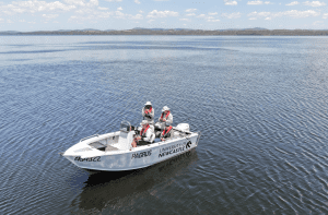
In early December, Mike Kinsela (University of Newcastle) assembled a team to return to the Myall Lakes area. Mike secured a University boat and kindly arranged for accommodation at Nerong (on an arm of The Broadwater). John Hudson (along with his drone gear) and I spent 3 days with him on the waterways; Dave Hanslow, who is very familiar with the area, came along for 2 days; and Tom Oliver equipped with OSL sampling tools joined us for the third day. We had two aims: first to check out rocky lake shores and islands, and second to secure samples for OSL dating of the sand ridges that occupy part of the Upper Myall River valley.
The weather had its moments. On day one the open boat got lashed with wind waves as we slowly made our way across Myall Lake. Skipper Mike did his best to keep us dry but as we turned back into the white caps we got a bit wet. Warm sun partly dried me. These conditions did not stop us from making some discoveries of vegetated cliffs and platforms but calmer waters were needed to see more. The next day gave us what was wished for with brilliant sunshine and at times a glassy surface until the sea breeze arrived at midday. What a contrast. Landings were not always easy given dense inshore reed growth yet we were able to get close enough to photograph shore features. John was able to use his drone on this day. The final day with Tom Oliver on board was devoted to reconnaissance and sand sampling along the Upper Myall River under rather hot and steamy conditions. Now boat shades could be used to give us some relief. A number of landings were made scrambling up river banks lined with Melaleuca and Casuarina trees. Towering, straight Eucalypts and Angophoras, along with flowering Banksias dominated on some of these ancient sand ridges.
Our findings on this trip confirmed what I had recorded in the 1965 paper. Near Bungwahl at the northern end on the Myall Lake “projecting promontories of country rock have been cliffed by waves. Irregularly shaped blocks rest on narrow rock platforms just above mean sea level” (p 5). Shepherd in his 1970 thesis went into more detail undertaking surveys around the shores of Kataway Hill and boulder deposits at Burrah Point (reproduced in 1992 monograph, figs 8.3, 8.4). We found many more examples occurring on different rock types within the folded Carboniferous sequence. How these tie in with ages of sand deposits to seaward and up the Upper Myall River remains to be seen. Obviously more work in this area is required before we can improve on our understanding of forces at work and over what time period. The fact that similar relict platforms and cliffs occur elsewhere on the NSW coast, such as at St Georges Basin, is providing us with much to think about.
I feel very fortunate to have returned to the Myall Lakes area after all these years for two reasons. First, to experience once again the natural beauty of the waterways. In some ways it remains “wild” with abundant tree cover around its shores, river banks and adjoining rock ridges and dunes; also there is the presence of different species of birds especially the swans; and it is a coastal haven with people. Second, to be with a team who are just as enthusiastic as me in unravelling the area’s secrets, especially with the next generation of leaders in coastal geomorphology, Mike and Tom. We are all learning from each other and that is very stimulating.
Bruce Thom
Words by Prof Bruce Thom. Please respect the author’s thoughts and reference appropriately: (c) ACS, 2025. For correspondence about this blog post please email admin@australiancoastalsociety.org.au
#287