Rock movement on rock platforms

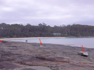
Photo of rocks on Bawley Point that had been moved by waves during the June storm, 2016. Photo taken by Roger McLean.
The June storms of 2016 have given rise to considerable commentary on beach erosion, and subsequent sand recovery. There were also some noticeable movements of large rocks on rock platforms. Such movements are not uncommon along the NSW coast although they are infrequently reported which often leads to debates about process and timing of past rock movements.
I recently visited Bawley Point on the NSW South Coast with Roger McLean. Roger has been visiting the area for ten years and been observing rock displacements. Bawley Point is formed by a remarkable rock type, essexite, an igneous rock intruded into the Permian sediments of the southern Sydney Basin. Just south of Bawley Point is Gannet Beach. On the southern headland of Gannet Beach, referred to by local surfers as “Moonlights”, Roger has been measuring movements of different sized blocks since the Pasha Bulker storm of June 2007. In the June 2016 storm he observed the power of the huge waves striking the coast from the north-northeast which led to run-up on exposed north-facing platforms of around 7 to 8m above MSL. He subsequently noted the movement of existing blocks and emplacement of new blocks that had previously been below low water and were now overturned on the sloping surface of the rock platform. At “The” Bawley Point to the north, similar movements occurred. John Hudson who also has a home at Bawley Point, noted rock movements on Wilfords Point about 1.5km south of “Moonlights”(see Photo). Some of these rectangular shaped blocks weigh several tons.
Essexite block on rock platform near Wilfords Point, South Coast NSW. Block has been pushed up from edge of platform and overturned to show oysters. Photo taken 5/11/16 by Ann Hinchliffe.
Following the 1974 storms, I noted many large blocks up to a metre in length had been thrown up onto the horizontal rock platform at Broulee Headland. These rocks are basaltic and formed as Tertiary lava flows. Oysters that had been growing on the undersides were now exposed on the overturned blocks and one could see scrape marks left where the blocks had been pushed across the platform. Unfortunately I did not take any notes of the block sizes or abundance at the time, but recall showing them to visitors on field trips to the area. I had spent time underwater at Broulee Headland exploring the overhangs and the fractures in the basalt and could surmise how easily it may have been to dislodge such blocks under high waves coming in this case from the south to southeast.
All this leads me to the excellent recent paper by Doug Booth in Geographical Research (54, 4, 357-364) on Bondi’s Big Rock: explanations and representations in coastal geomorphology. Doug has explored the various interpretations on the origin of this large 235 ton boulder that sits on the sandstone platform at Ben Buckler. As a local, I always referred to this rock as the “Mermaid Rock” in honour or dishonour of the stolen and damaged statues of mermaids placed on the block in the 1960s and removed by students from Sydney University (not me!).
Doug discusses the observations and interpretations of those who have shown an interest in storm wave and tsunami impacts on the NSW coast. The July storm of 1912 has been cited in the geological literature as the time the rock was cast up. As noted by E.C. Andrews in his 1916 paper on shoreline movements on the sand foreshores of Botany Bay, this was a major storm event. However, in his paper, Doug discusses the views of others who claim the Big Rock existed before 1912. I have a pre-1912 photo that indicates a rock was on this platform pre-1912, but was it the Big Rock? Doug concludes that the story of the Big Rock is a nice example of how explanations and representations of the experience of extreme events can “…vary according to how they prefigure, choose, contextualise, theorise and conceptualise their evidence, configure their language, deal with contradictory evidence, and ignore and/or confront silences”.
The lesson from 2016 and from past records and studies is the need to make careful observations of features of interest following major coastal storms. Extreme events can have varying impacts in different coastal places and the June 2016 event provided us with insights that were different from 1974. Doug Booth has alerted us to the importance of documenting impacts as soon as possible after an extreme event and getting the observations cross-referenced with those of others. At the NSW Coastal Conference this year we saw examples of exactly that in relation to wave erosion impacts on beaches. What Roger McLean is doing at Bawley Point is another example which is highlighting changes that are occurring on the rocky headlands and platforms of our coast. By careful and repeated measurements of rock movements on platforms we can obtain a better understanding of how wave processes can modify these coastal features during extreme events.
Words by Prof Bruce Thom. Please respect Bruce Thom’s thoughts and reference where appropriately: (c) ACS, 2016, posted 18th December 2016, for correspondence about this blog post please email admin@australiancoastalsociety.org

