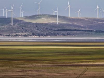
LAKE SHORELINES: Lake George

Lake George (photo source: The Silent Theory)
I have just driven back from Canberra. This drive makes me wonder about the geology and geomorphology of Lake George.
One really appreciates its majesty as you descend the scarp from the south and glimpse at the now dry expanse of the lake bed (and the glorious wind farms beyond!). As you skirt the western shore below the scarp I recall being able to throw a stone from a parking lot into the water in 1988. Not today, it is dry. In historic time water comes and goes even allowing sailing in the 50s when tragically some Duntroon cadets drowned. Many wild theories have been invoked to explain the changes in water levels, but hydrological studies suggest we are basically dealing here with a grand evaporimeter.
I was first introduced to its shoreline features as an undergraduate by one of the fathers of modern geomorphology in Australia, the late Joe Jennings. He pointed out the ridges at the northern end and showed me the location of pits to inspect the gravel deposits. But that was then. He later supervised a PhD student, Ross Coventry, to work on these and other lake shore features as well as encouraging palaeo-biologists such as the late Gurdip Singh from ANU to look at the pollen and charcoal record. Since then other Quaternary studies have been undertaken to further develop and revise the record of deposition.
Let us go back one step, to at least the Miocene, 20-30 million years ago. At this time a geologic fault occurred on the west side of the lake blocking drainage. Since then sediments over 200 metres thick have built up the lake floor. However, the shoreline history that intrigues me is probably less than 100000 years although more dating needs to be done to confirm with any degree of precision the age of landforms.
The scarp is formed of old folded rocks, cut by gullies, and covered in part with alluvial fans. Signs alert drivers to the possibility of encountering fallen rocks and road works have taken into account runoff and sediment movements near the road. It is evident that during the Last Glacial period from around 100000 to 10000 years ago rock supply has been available for longshore sediment transport at times of high lake levels. This becomes clear as you approach the northern end of the lake and the highway swings to the right along a ridge then bends left before heading due north. What you have driven over is a classic recurved spit composed of sand and rounded gravels which have been mined in a couple of places ( not anymore I’m afraid to say!). This spit encloses a relic lagoon containing drainage ditches. Continue north towards Collector and ahead lies another ridge at right angles to the road. This is the highest and oldest shoreline feature, a gravel barrier, again blocking off an old lagoon. It stands 30-37m above present lake floor. Sand sheets occur on the eastern side of the lake not seen from the road.
Coventry explained these shorelines and sand sheets in the context of climate shifts during the Last Glacial. Micro-fossils point to periods of sustained high levels of fresh water, periods of more saline water and dry periods. The shorelines at the northern end involve higher lake levels, probably several episodes going back to around 60000 years at least for the older barrier ridge. Waves from the south must have been powerful enough over a long enough period to work the rock material into gravels. The beautiful recurved spit is obviously younger, occurs at a lower level and involved movement off the scarp slope deposits with waves driving the gravels from the south and south west. Sand sheets on the east side probably reflect drier periods under the influence of westerly winds.
When I think about these features., I am reminded of the great work by G.K. Gilbert of the US Geological Survey. He published a report on Lake Bonneville in Utah in 1890. This monograph set the study of shoreline phenomena on a scientific path. Yet it was conducted on features bordering a relic Quaternary lake basin! He observed cliffs, wave-cut terraces, beaches and barriers, spits, dunes, deltas and the characteristics of sediments that made up many of these features. He provided clear explanations of their origin and history. Many of the principles that underpin coastal geomorphology can be found in this study. Hence the fascination for me and others of lake shorelines.
– words by Prof. Bruce Thom


 VIC Coastal Awards