Coasts and the military

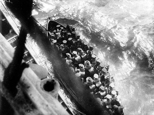
6th Battalion soldiers leaving the transport ship, 25 April 1915 (photo source: flickr.com)
On this the day after ANZAC Day, I reflect on various ways I have been influenced by the military. My father served in the First AIF, 4th Division, in France. Between 1962 and 1971, the Office of Naval Research (ONR), US Navy, sponsored me in a number of projects including PhD studies at the Coastal Studies Institute, LSU. And from 1977 to 1984, I had the privilege of being at the Royal Military College Duntroon as a member of the Faculty of Military Studies, UNSW.
I cannot help thinking of how important an understanding of coastal environments has been to military campaigns. History is full of invasions from the sea, but at this time we think and hear a lot about Gallipoli. Over the last few weeks, there have been many images of landings on 25 April in what appeared to be relatively calm conditions onto a narrow beach backed by steep, gullied ravines. What prior knowledge did those in command have of these conditions?
In my reading about D-Day landings at Normandy in World War II, it was apparent that a considerable amount of prior investigation was carried out. I recall the incredible efforts of those sent out under cover of darkness from a submarine to take core samples of nearshore and beach areas to determine strength of the surfaces to be traversed by heavy landing craft. But other studies were needed of waves, tides, sand transport and ridge and runnel formation that characterised these beaches. Some of these are summarised in that epic 1959 text by C.A.M. King on Beaches and Coasts. I have long admired the war studies of Bill Williams, who later published in the Geographical Journal (for instance in 1947 on “The determination of the gradient of enemy held beaches”, vol. 109). Americans also had immense and often painful experience of landings in the Pacific, on atolls and island shores. Again attempts were made to forecast conditions using various techniques including aerial photos. The Australian War Memorial has a collection of much of their work aided by Australian Intelligence staff. One classic photo was of the terraces of Huon Peninsula in PNG first cited by a former Australian officer, later coastal expert, Rhodes Fairbridge. What these terraces meant required subsequent field studies by John Chappell who famously mapped and dated one of the greatest raised reef sequences in the world.
ONR realised after WWII that more needed to been known about coastal processes, history, landforms and sediment types. The USGS also was very active especially in the Pacific in preparation for atomic tests through studies of atoll geology. The Geography Branch of ONR was headed by an amazing women, Evelyn Pruitt, and she set out to invest in universities that had coastal programs. LSU was one such place under the leadership of Richard J. Russell. Beachrock had caused many casualties during that war stimulating Russell and some students to work on their distribution, petrology and origin. Deltas were the focus of many studies especially given the Louisiana location and the US growing engagement in Vietnam. Staff and students were sent all over the world. I was fortunate to be sent as a graduate student to Tabasco in Mexico, and later whilst on staff at ANU to join a team led by Don Wright to the Ord delta system in WA. I also studied coastal landform history in South Carolina; on one field trip ONR kindly provided me with a Navy jeep for transport! These were magic times for me working with many coastal scientists in studies of wave processes, beach dynamics, sedimentation, delta formation and coastal evolution. Andy Short also had a great time at LSU with his Arctic research (and playing rugby).
A disappointment to me on arrival at Duntroon (in 1977) occurred when I tried to engage the Australian defence establishment in supporting research on coasts similar to that I had undertaken at LSU and ANU. There was no interest. Many excuses were offered, but the message was that there was no need for scientific studies of conditions where amphibious landings may or may not occur in future. This was in contrast to the continuing interest by the US Army Corps of Engineers, ONR and the Marine Corps in building their knowledge base. It is apparent to me that much Australian academic research remains relevant to military operations and planning. I have held some discussions on potential climate change impacts on coasts with defence personnel, and there have been some useful products arising, for instance, through the former Climate Adaptation Program. And some Navy staff were interested in our bottom profiles of the Cootamundra Shoals north of Darwin surveyed during the 1982 joint UK-ANU expedition led by Nick Flemming; they knew very little about this area of drowned reefs at the time.
But I do not see on-going investment in knowledge sharing or field/modelling studies that could offer stronger support for our armed services. Perhaps I am missing something; I can only hope that there are some useful programs out there in defence land that are held in secret as “operational matters” which are based on good coastal science.
Words by Prof. Bruce Thom


 ESTUARINE WATER LEVELS