


Bribie Island: Harbinger Of Changes To Come?
Recent tropical cyclones in southeast Queensland have impacted in ways that truly challenge coastal managers, governments and communities. One location where this is most evident is the northern end of Bribie Island and adjacent settlements. It is an area that offers a warning of (or signpost to) future change, not just here but elsewhere along the eastern Australian coast.
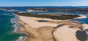
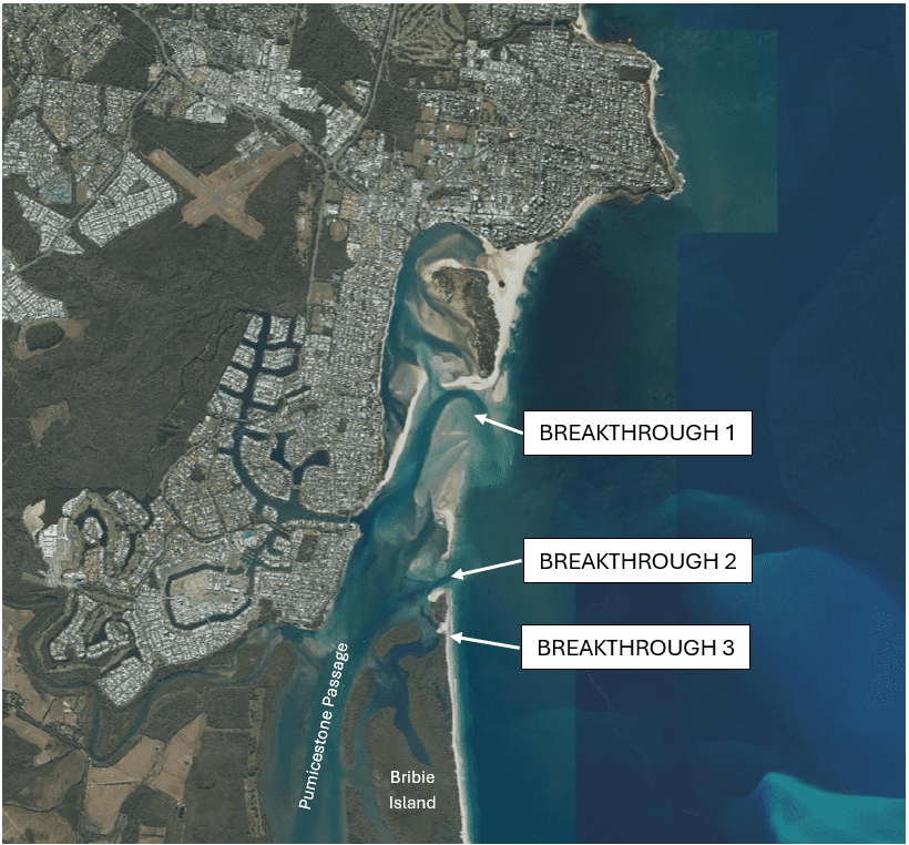
Before diving into the specifics of the problem as exemplified by coastal changes at Bribie Island, a little context is required. This sand mass is the northernmost of three that occur at the mouth of Moreton Bay. Unlike Stradbroke and Moreton islands, Bribie is a low-relief sand barrier formed in the late Pleistocene (Last Interglacial MIS 5e ?). Its beach, dune and backbarrier deposits are underlain by “coffee rock” (humic impregnated sand). It is separated from low-lying land to the west by the 34 km long Pumicestone Passage. At the northern end of the island a thin barrier spit of Holocene age sits on top of coffee rock which outcrops offshore.
As far back as 1968 the Queensland Government has been compiling reports on the dynamics of this northern end of Bribie Island. Pumicestone Passage and changes in entrance conditions were noted in the Delft Hydraulics Report 1970. In its detailed coastal erosion study of SE Queensland, there was an alert that the entrance could change location as a result of breakthroughs impacting on the settlement at Golden Beach located on the western shore of the Passage. The report noted “It is clear that in a permanently shifting and changing system no static equilibrium can exist”. What prescient words!
Moving forward to 2025, and many studies later, the Queensland Government has responded to reviews of consultants on Bribie Island erosion and breakthroughs that have been of great concern to Sunshine Coast Council and communities in the vicinity of Golden Beach and Caloundra. These reviews can be found at:
- Bribie Island erosion and breakthrough review | State Development, Infrastructure and Planning
- Bribie Island emergency works | Office of the Coordinator-General
What promoted these reviews and the initial Government decision to spend $20m on emergency works that would be exempt from usual scrutiny through environmental planning and approvals processes? First, breakthrough of the Bribie Island spit in January 2022 following beach and foredune erosion associated with Cyclone Seth led to the migration and widening of a new channel entrance to the south. The result was multiple impacts including increased tidal range within the Passage and exposure at Golden Beach to wave forces including storm surge inundation. Second, Cyclone Alfred in February/March 2025 initiated further breakthroughs to the south of that associated with Cyclone Seth (see map). The reviews reported that other sections of the narrow island were degrading and vulnerable to overwash. There was a “risk of full loss in the near term…as the island’s natural buffer function is further diminished”.
In response to these dynamic changes the Queensland Government directed the Coordinator-General to undertake emergency works. Sunshine Coast ABC news on 13 November 2025 reported on “Bribie Island officially reconnected as workers close breakthrough”. At this time sand pumping had “fixed” the Alfred second breakthrough with further work continuing to close the breakthrough that formed during Cyclone Seth. A “mountain of sand between 80-100 m wide and 3m above the highest high tide” was being built up. This was the first of several stages required to build the island buffer and improve navigation and waterway health of the tidal channel. Local residents were very pleased. Expectations are high: “What we’ve managed to achieve by putting the island back together is to protect this beautiful waterway” one said; the local Coast Guard Commander is quoted as saying the “work will offer complete protection to Golden Beach residents”. Is there not a false level of confidence in all this?
The consultants also pointed to the need for longer term solutions that would “reinstate Bribie Island” to enhance “long term resilience” and restore “the islands original barrier function”. This could involve a hybrid of nature-based and engineering solutions. Ten options were proposed including a multipurpose artificial reef, ‘soft’ groynes for entrance stabilisation, and an increased sand and dune buffer along Golden Beach in conjunction with buried seawalls inside the Passage. In its response, the Queensland Government has indicated that the current emergency works will inform the design of long-term actions. It recognises “the importance of long-term management of the passage after years of inaction and neglect” even to the extent of “establishing the Sunshine Coast Waterways Authority to invest in ongoing protection and coastal resilience”.
What does all this tell us? Fragility of the sand barrier at the northern end of Bribie Island has long been recognised. The 1970 Delft Report identified bidirectional longshore sand transport and entrance instability. Subsequent studies have shown that large waves from tropical cyclones continue to induce recession of the shoreline. Sand is transported to the southern end of Bribie Island and into the tidal entrances. The existence of widespread coffee rock patches offshore indicates quite low rates of cross-shore sand transport hence a negative sediment budget. The beach system is detached from extensive sand shoals that occur north of Moreton Island by a deep channel. One conclusion from a study by BMT was that there does not appear to be a physical natural mechanism for sand to move from the southern part of Bribie Island to the northern part of the Island.
At a smaller scale what we are witnessing at the north end of Bribie Island has been well documented on the Outer Banks of North Carolina. Here attempts to manage impacts have had many adverse consequences. Inlet migration and temporary widening, storm surge overwash and inundation, sand sequestration into tidal deltas, and shoreline recession all come together to degrade the beach-dune buffer. As a result, properties and infrastructure are at risk where located in proximity to that eroding buffer. I also see what is occurring here simulates to a degree conditions along the east coast when sea level was rising at a decreasing rate towards the end of the Postglacial Marine Transgression (c. 8000 yrs ago); but that is another story.
Here lies the warning that the Bribie experience is offering other coastal compartments as sea level continues to rise (and coastal storms get more severe). As the natural buffer gets degraded vulnerability increases for low-lying settlements. This is not just because of shoreline recession. Inlet expansion and deepening along with storm surge inundation will become more evident. Protecting Golden Beach will come at a cost no matter what long-term options are selected. Local residents need to appreciate that there is no easy solution to maintaining their “beautiful waterway” and protection provided by a “reconnected” Bribie Island.
Bruce Thom (with thanks to Paul Prenzler for information)
Words by Prof Bruce Thom. Please respect the author’s thoughts and reference appropriately: (c) ACS, 2026. For correspondence about this blog post please email admin@australiancoastalsociety.org.au
#290