


2025 Coastal Storm Season: Waiting For The “Big One”?
Ever since we started measuring beach profiles at Bengello Beach, Moruya, in the 1970s, Roger McLean and I have contemplated the recurrence of the 74-78 erosion phase. In the 50 plus years of record this phase stood out (see McLean et al., Geomorphology, 2023, 108850). We noted in that paper that impacts of the scale observed in 1974 have not been paralleled by subsequent storms to 2022 (now to April 2025). I discussed the series of 1974 storms last year in Blogs 259, 260 and 261.
Here I want to briefly explore two questions: First, are we experiencing a set of meteorological/oceanic conditions similar to 1974 that are preconditioning our beaches for a more massive “culminating” event later in the year? Second, does the geological record of the last several hundred years offer evidence that what occurred in the mid-70s along the NSW and Southern Queensland coast is repeatable at a similar or greater scale?
It has been tempting over many years to get excited by the occurrence of large storms (e.g. 2007, 2016) that have impacted beaches, dunes and infrastructure along this coast. Mitch Harley, Tom Mortlock and their respective colleagues have analysed these various events in considerable detail. Back in 1978 I undertook a historical review of contemporary coastal erosion events (see Chapter 9 in Davies and Williams eds, Landform Evolution in Australia, ANU Press). I recognised 5 phases of an erosional event that constituted a sequence (or cluster) of separate storms driven by favourable hydrodynamic conditions:
- Preparation of a steep beachface involving storms in the previous year.
- Summer erosion as a result of effects of a tropical cyclone in southern Queensland.
- Autumn erosion from mid-latitude cyclones leading to further beachface erosion.
- “Culminating” disastrous storm(s) in winter from intense east coast low(s) with massive offshore sand transport.
- Maintenance of erosive conditions sustaining dune cliff instability and limiting full beach/foredune recovery.
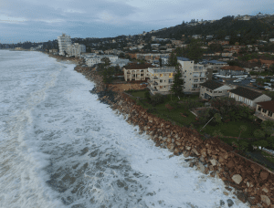
What we are noting in 2025 is a similar pattern through to Phase 3. Beaches in many but not all compartments have been primed for later impact as sand moved into offshore bars and incipient foredunes were trimmed. In 1974, Cyclones Wanda and Zoe moved south; this year Albert has made its presence felt. And in April two very different depressions developed off the east coast, cutting back the beaches and foredunes. All this time ocean water temperatures have remained high just as in 1974. As of late April the temperature is 23 degrees C off Sydney.
So in response to the first question, we must wait with great trepidation as to whether Phase 4 will occur with damages equal to or greater that the May-June “culminating” storms of 1974.
The second question stems from work over the last decade or so by different groups that have explored the geological archive contained within east coast foredune systems. Has the extreme beach retreat in SE Australia in the 1970s been a one-off event over recent centuries? If not, then are we underestimating storm erosion demand volumes from cumulative storm erosion events in using 1974 as a reference in hazard assessment ? To answer these questions an array of field and statistical methods have been used to uncover the record of past events.
Ian Goodwin and his team prepared a technical reports for the NSW Government in 2015 as part of the Eastern Seaboard Climate Change Initiative on East Coast Lows (ECLs). Project 4 specifically examined the “Coastal system response to extreme ECL clusters in the geohistorical archive” (Climate Futures @MQ Report). This was a statewide study using GPS topographic survey, GPR mapping of the subsurface, and OSL dating techniques. Some of this work has appeared in subsequent publications (e.g. Goodwin et al., Chapter 25 in Jackson and Short eds., 2020, Sandy Beach Morphodynamics, Elsevier). They demonstrate how sedimentary signatures can help define extreme storm activity by different storm types, distinguishing between those with waves generated from easterly-east southeasterly compared to those from more persistent southeasterly waves. In some compartments they were able to define what they referred to as the “ultimate storm scarp”. Its position is taken as the pre- 1820s recessed coastal planform and inlet configuration that denotes the erosion limit during the 1700s storm clusters. The NSW coast contains “ubiquitous signatures of higher wave power and frequency of extreme storm waves over the 1600-1900 period…this period was the highest frequency ECL storm wave climate in the past millennium”. Their advice is that future storm hazard and risk analysis for the southeast Australian coast should be based on the 1600-1900 period using a clustered statistics approach involving more recent storm events.
A more localised geohistory of recent centuries has emerged using similar methods at Bengello Beach, Moruya. Here Tamura, Oliver, Dougherty and others have attempted to reconstruct past phases of shoreline accretion and post-storm beach recovery buried under foredunes. They compared the results with beach measurements over the last five decades. This compartment has been experiencing continued accretion separated by episodes of erosion as demonstrated in Tamura et al. (“Recurrence of extreme coastal erosion in SE Australia beyond historical timescales inferred from beach ridge morphostratigraphy”, Geophysical Research Letters, 2019, 46, 10.1029/2019GL08306).
Tamura et al. conclude that the 1970s extreme beach retreat was not a one-off event. It happened at least once around 1650-1700. Distinct phases are recognised of rapid beach recovery accretion separated by intervening gradual accretion. These phases of gradual accretion are consistent with the overall accretion rate of c. 0.2 m/yr of the 6000-year-old prograded strand plain. Both post-storm rapid beach accretion phases in 1650-1700 and 1978-1983 have been preserved in both northern and southern parts of Bengello Beach. It is suggested that the period between c. 1700 and 1970s scarp, interpreted as a gradual phase of beach progradation, could be the result of several episodes of beach erosion and recovery and that “recurrence of extreme beach retreat with less than a few hundred years interval should be taken into account for coastal planning in the region”.
These studies highlight the dynamic nature of beach/foredune systems over the last several hundred years. My single C14 date of 300 years on an exhumed Banksia stump within an exhumed soil profile in the now active Stockton Bight dune sheet, noted in that 1978 paper mentioned above, made me alert to dramatic changes in our coastal landscapes prior to European settlement. But NSW Government has defined a “beach fluctuation zone” in strictly historical terms linked to our 1970s experience. In Section 4 of the Coastal Management Act 2016, it is the range of natural locations a beach profile occupies from its fully accreted condition to its fully eroded condition with a landward limit defined by the escarpment resulting from the erosion associated with a 1% storm event or a more extreme event of record, whichever is the landward limit.
The question is whether we have fully appreciated the geohistorical archive present in the foredunes in defining the “beach fluctuation zone”. And is a bigger storm event on its way?
Bruce Thom
Words by Prof Bruce Thom. Please respect the author’s thoughts and reference appropriately: (c) ACS, 2025. For correspondence about this blog post please email admin@australiancoastalsociety.org.au
#276