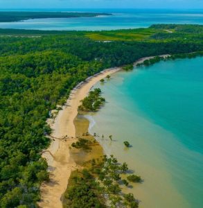
Geodiversity Part 2: Kimberley Coast
My blog on Australian coastal geodiversity prompted a reminder that I had not referenced the work of Victor Semeniuk and his colleague Margaret Brocx. Both Andy Short and Colin Woodroffe provided me with references that I should have cited. In retrospect, this failure is inexcusable as I was involved in a geoheritage review with one of these authors at the southern end of the Kimberley coast.
About 20 years ago I was asked by the Western Australian EPA to comment on the geoheritage values of mangroves and tidal flats in King Sound near Derby. A tidal power station was planned in the area. Vic Semeniuk had submitted to the EPA the geoheritage case for protection of the landforms and ecosystems given previous studies (see V. Semeniuk and M. Brocx, 2011, “King Sound and the tide-dominated delta of the Fitzroy River: their geoheritage values”, Journal Royal Society Western Australia, v. 94, 151-160). I supported his arguments, but the proposal failed largely as a result of cheaper energy from nearby gas fields.
In my previous blog I identified the rocky Kimberley coast as offering suites of landforms reflecting long-time scale responses to different sets of process at a regional scale. Here is where I should have referred to the very informative 2011 paper by M. Brocx and V. Semeniuk ( “The global geoheritage significance of the Kimberley Coast, Western Australia”, Journal of the Royal Society of Western Australia, v. 94, 57-88). This is one of a number of papers that they have published on geoheritage mostly in the J. Royal Soc. WA (e.g. v. 90, 53-87, 2007; v. 92, 243-260, 2009; v. 93, 81-113, 2010).
According to these authors the Kimberley coast is of “global geoheritage significance”. It is a coast cut into Precambrian rocks revealing an incredible story of a sedimentary basin and subsequent tectonics that dates back so far in the history of the planet. The region can be geologically divided into two: the ancient sandstones and basalt to the north and the folded sedimentary and metamorphic rocks of the King Leopold Orogen to the south. As a large-scale ria or drowned valley coast, its indented rocky shores highlight features of the geology given the effects of erosion on the different rock types. To them this provides a “global classroom” where rock exposures and landforms are so clearly displayed. In their words: “The coastal forms in the Kimberley region have been determined by the structure and lithology of the regional geology, interfaces between major geological units, by marine inundation of onshore landforms, and by the sizes, shapes and configuration of rivers, creeks, their tributaries, and other valley tracts of the region”. However, they also stress other landforms associated with deposition in gulfs and embayments with “cliff shores fringed by mangroves” and muddy tidal flats, spits, cheniers, and locally along the open coast the algal reefs, coral reefs, and beach rock.
What is also important about the work of Semeniuk and Brocx is how they place regional studies into a broader methodological context to assess features of geoheritage significance. They have developed a “tool-kit” which can be applied across a range of scales that reflect different levels of significance: International, National, State/Regional. Figure 13 in the 2011 paper shows how the tool-kit can be applied to the Kimberley coast. This figure uses photos to demonstrate the range of features included in their Kimberley tool-kit.
I did list the False Mouths of the Ord as one of my 12 favourite “geodiverse sites” in the last blog. The Ord/Cambridge Gulf is at the eastern end of the Kimberley coast. It was discussed in a paper on mangrove and coastal geomorphology co-authored with Don Wright and Jim Coleman in 1975 (Journal of Ecology, v. 63, 203-232). We also undertook a regional study of geomorphic coastal variability (geodiversity), including the eastern Kimberley rocky coast, in a report prepared for our sponsoring organization, the Geography Branch , US Office of Naval Research (published in Coastal Studies Bulletin, LSU, No. 7, 35-64, January 1973). This study moved beyond the main deltaic focus of the Coastal Studies Institute program. It divided the coast between Darwin and eastern Kimberley into “provinces” each of which is characterized by a distinctive combination of coastal geomorphic features reflecting relative contributions from different process factors. In this way we showed how the study region, because of “feedback” between form and process, exhibited variations in resistance factors (geologic structure, coastline orientation, and offshore slope), together with variations in sediment supply, create appreciable spatial variability in the nearshore process environment thereby influencing the contribution of different process factors to the coastal geomorphology. Here in our Kimberley region study we have a forerunner to the theory of coastal morphodynamics that Don and I wrote up much later (1977, Progress in Physical Geography, v. 1, 331-359).
In providing a clear systematic model to describe sites and regions of geoheritage and geodiversity, Semeniuk and Brocx have gone way beyond what we reported from our 1971-72 field studies in northwestern WA. For those interested in geodiversity and geoheritage they have provided the platform from which we can all aspire.
Bruce Thom
Words by Prof Bruce Thom. Please respect the author’s thoughts and reference appropriately: (c) ACS, 2024. For correspondence about this blog post please email admin@australiancoastalsociety.org.au
#267

