DISCOVERING MORUYA 1971-2021

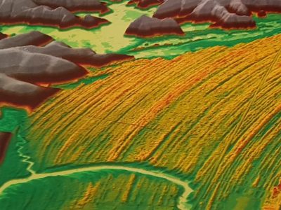
Moruya Beach (NSW) beach ridge plain digital elevation model derived from LiDAR (Source. Tom Oliver)
Fifty years ago I had my first encounter with the Moruya River, the town, the airport, the old granite quarry, and the beach system to the north of the river entrance. Ever since this area has been one of great importance on the NSW coast, the focus of attention not just by me but by many others interested in coastal evolution and dynamics. It remains so today attracting folk like Andy Short to live close by.
All this started while undertaking reconnaissance soon after commencing as a Research Fellow in Biogeography and Geomorphology at ANU early in 1971. The then acting head of department, Joe Jennings, kindly approved of the hire of a caravan and with family in tow we spent two months looking at sites from Gold Coast to Mallacoota. The NSW south coast was a mystery to me at this time and it was a pleasure to meet Bob Young early on to learn more about interesting places to visit. Bob was a fellow geography student at Sydney in the late 50s. He was on staff at University of Wollongong living at Kiama Downs; there we poured over some air photos and he pointed to the set of what we called beach ridges in the bay north of the Moruya River. I was looking for places to drill some holes if only I could get my hands on a drill rig; this embayment looked ideal, and so it turned out to be.
Back at ANU the case was made to acquire a rig and a driller so by 1972 the stage was set to start morphostratigraphic investigations of coastal sand deposits at Moruya and elsewhere in southeast Australia. Karl Shaw, the driller, had the capacity to retrieve considerable material to depths of c. 30 m below this beach/foredune ridge or strand plain. Karl and I spent the next two decades on and off drilling in many places; it was a voyage of continuous discovery made possible by his tremendous skill and my good fortune of having those 5 years at ANU with its radiocarbon and other laboratory facilities, to get started at places like Moruya.
What we found beneath the surface raised questions about modern environments of deposition on the beachface and offshore, and later in estuaries. We had to learn to dive. A crash scuba course followed, and many hours were spent beyond the breaker zone and seaward of the rock platforms to the north of the river and around Broulee Headland and Island. This provided evidence of shell type and sand composition highlighting the compartmental nature of this section of the coast that remains a fascinating subject of study today. Our understanding of the late Quaternary evolution of the area continues to grow with drilling of the blocked swamps such as Waldrons, and the flood plain near the town, together with finding buried rock platforms and relict cliff faces. It was a treasure trove waiting to be uncovered. Greg Bowman looked at soil profile changes and Tom Oliver has demonstrated the power of OSL, GPR and LiDAR in his detailed analysis of Holocene evolution of embayments north and south of the Moruya River.
Late in 71 another opportunity arose to spend time at Moruya and Broulee. I had met Ian Eliot who was undertaking a PhD at ANU supervised by John Chappell. Ian’s study area was Durras Beach north of Batemans Bay. We talked about establishing a site for long term monitoring of beach change at relatively easy access to Canberra. Years before I had learnt from Alec Costin, CSIRO Alpine Ecology Unit, of the value of systematic monitoring while employed as his field assistant. The need to justify frequent trips to what we now call Bengello Beach from Canberra gave rise to the opportunity to set up several stations to measure foredune, beach and nearshore change. Ian and I designed the basic layout of profiles that continues to be measured at regular intervals by Roger McLean. Rog joined the group at ANU while I was there and quickly got involved in the program. Don Wright arrived at Sydney University in 1974 and commenced his morphodynamic studies; one of his sites was in the vicinity of the profiles on Bengello Beach. So the treasure trove on information grew with insights into beach dynamics. This continues as Rog explores the implications of 50 years of measurements of beach and foredune change. Here we were fortunate to capture various storm events and the nature of post-storm recovery, more on this story next year.
What an enormous privilege it has been to have discovered Moruya. I have been able to work with great colleagues and to have been able to help those who in turn acquired new knowledge of this wonderful area. It remains one of the most rewarding field laboratories on the NSW coast with more to be gained from both offshore and onshore field research.
Bruce Thom
Words by Prof Bruce Thom. Please respect the author’s thoughts and reference appropriately: (c) ACS, 2021. For correspondence about this blog post please email austcoastsoc@gmail.com
#206


 PROTECTING A BIG CITY: NEW YORK DECISION MAKING