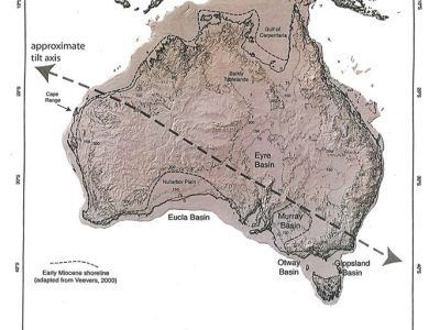
The Sandiford Line

(Diagram Source: M.Sandiford, 2007, Earth and Planetary Science Letters 261, 152-163)
Meanderings around the Australian coast excite one’s interests in so many weird and wonderful ways. Long ago I was fascinated by the writings of Reg Sprigg on the elevated palaeo-shorelines of South Australia (1952, Geol. Survey South Australia, Bulletin, 29). They stood in strong contrast to anything I had observed in NSW and southern Queensland. Where were the beach and dune deposits of 50m or more above present sea level that Sprigg and later many others were documenting in SW Victoria, South Australia and WA? And in the early 1970s on travelling north to the Great Barrier Reef, into the Gulf of Carpentaria, and on to the eastern Kimberley’s, I had trouble even locating evidence of the Last Interglacial. At least we could detect shoreline and estuarine deposits of that age in central and northern NSW above present sea level!
John Veevers in 1984 in his epic Phanerozoic Earth History of Australia (Oxford University Press), was the first to draw attention to the asymmetric distribution of marine and nearshore Cainozoic sediments around the Australian margin. In 2007, Mike Sandiford brought a lot of the work together on this point in a paper on the “Tilting Continent” (Earth and Planetary Science Letters, 261, 152-163). In that paper he states:
“One of the most extraordinary features of the Australian Cainozoic record is the profound asymmetry in the distribution and stratigraphic relations of marginal marine sequences, reflected ultimately in the contrasting present-day morphotectonic character of the northern and southern continental shelves. Stratigraphic relationships indicate that this morphometric asymmetry developed in the mid-late Neogene, after about 15 Ma” (p.158).
In that paper, Sandiford, produced a figure (Fig, 3, p.155) with a thick, arrowed line crossing the continent from NW to SE. This line, which I term the Sandiford Line, shows the approximate tilt axis demarcating the region of the continent that contains onshore marine Miocene to the south and west from the region to the north and east that has no onshore marine Miocene record. He notes that along the northern margin with its broad continental shelf, sea levels are currently as high as at any stage during the Neogene. In contrast, the southern sector possesses what he terms a progressive offlap of palaeo-shorelines in places hundreds of kilometres inland and at elevations up to c. 250m above present-day sea level. In explaining this asymmetrical distribution, he says it “demands a relative NNE-down, SSW-up apparent vertical motion”; he goes on to link this to variations in the dynamic topography and the geoid associated with plate motion and the subduction realm to the north. Further discussion of these processes can be found in another paper involving Sandiford: Tectonic geomorphology of Australia, M. Quigley et al.,2010, Australian Landscapes, ed. Bishop and Pillans, Geological Society, London, p.243-266).
It is interesting to read in Sandiford that it seems extraordinary that the idea of Australia as the “tilting continent” has not received more attention: the conclusion “is stunningly obvious” (p.158). He notes that one of the few studies to infer such tilting was by Colin Murray-Wallace and Tony Belperio in 1991 (Quaternary Science Reviews, 10, 441-461). This review paper was an important contribution and was based on the differences in elevation above present sea level of Last Interglacial features. They cited discussions with Kurt Lambeck. During the 1980s there were several us, including Kurt and John Chappell, who were interested in explaining differences in elevation of Holocene and Pleistocene marine deposits. Aspects of this work was discussed to some extent in papers in the volume I edited in 1984 on Coastal Geomorphology in Australia (Academic Press; for instance, papers on northern Tasmanian emergent shorelines by Bowden and Colhoun, and by Schwebel on SE South Australia).
The Sandiford Line and the concept of a tilting continent offers us a neat mega-scale way of understanding the tectonic framework of Tertiary to Quaternary coastal evolution around the Australian continental margin. When a group of us set out to explain the east Australian marine abrasion surface we were conscious of working with a subsiding continental margin. Ancient rocks that formed the margin in association with the opening of the Tasman Sea were subject to marine planation as sea levels progressively rose towards present since the mid-Oligocene (see Fig.9 in Thom et al., 2010, in Bishop and Pillans, eds., Australian Landscapes). This interpretation was broadly consistent with the more general model of Cainozoic sedimentation that Peter Roy and I put together in 1981 (J. Geol. Soc. Aust., 28, 471-489). These studies fall into a region that lies north of the Sandiford Line.
Bruce Thom
Words by Prof Bruce Thom. Please respect the author’s thoughts and reference appropriately: (c) ACS, 2019, for correspondence about this blog post please email austcoastsoc@gmail.com
#141


 A Curiosity of Cusps