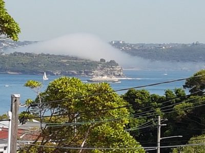
Sydney Harbour Sea Fog – Summer of 2018/2019

Sea fog has been a regular occurrence this summer in Sydney Harbour. To hear fog horns sounding in the middle of the day is a rare experience. From our verandah we can see the fog as it rolls through the Heads into Middle Harbour. It seems to stall and bulge up as a mound still attached to the sea surface. We saw this on 17 December and again last Friday. The fog then expands down the Harbour and over the cliffs into Vaucluse along the lines of our local valley and streets. Later in the afternoon it dissipates.
Much of all this has been captured online, especially the December event. It certainly provides a local cooling effect. I was reminded of my first day in San Francisco many years ago when a dense blanket of fog came over the hills to the west of the city off the ocean. This took place in the early afternoon in September. Here it is quite frequent given the cold offshore waters. What is required is a temperature difference between the ocean and the air above especially when that air is laden with moisture. The known process is for the warmer air to be cooled to dew point by the sea and for condensation to take place. If winds are light enough and coming onshore then the fog is driven slowly landward.
Is this what has happened in Sydney this summer? Bureau of Meteorology Meteye is a great tool to check on daily oceanic and atmospheric conditions. The swirl of the East Australian Current (EAC) is well displayed with its characteristic eddies. Huge temperature contrasts can be observed not just within eddies, but also towards the coast in the vicinity of Sydney (up to 7 degrees C). Pods of cooler water seem to reside just offshore. Are they trapped by some deeper ocean circulation process? Between 1981 and 2005 the mean water temperature at Bondi at this time of year is 22.9 C with a range of 21.2 to 24.4. This past week it has hovered around 21.7 getting down to 19.6 C on 11th. At the same time the water temperature in the outer harbour was 22.2 C. The air is quite humid and the fog is accompanied by a light onshore breeze. Conditions change with the arrival of a blustery southerly.
This summer north-easterly winds have been prevalent along the NSW coast. Such winds favour the invasion of our beaches with bluebottles. That is not uncommon. But there must be an additional factor to stimulate these midday summer fogs. A spokesperson for the Australian Coastal Society suggested the Ekman Spiral might be at work involving upwelling of colder water to the right hand side of the strong EAC. Weatherzone describes the sea fog forming as highly humid air moving ahead of a southerly change passes over relatively cooler ocean waters – causing the water in the air to condense, form fog and then be blown ashore. So cool ocean waters being developed through upwelling (Eckman Spiral) could very well be part of the larger picture described in the Weatherzone article. The topography of the coast and harbour appear a strong influence on where and how sea fog moves onshore. The topographic effect on the passage of the moisture-laden air flowing across the Sydney coast and into that funnel-shaped drowned valley of Sydney Harbour is a sight to behold. Conditions of cool ocean waters and warm moist are common this time of year and we may well see similar events this summer.
Bruce Thom
Words by Prof Bruce Thom. Please respect the author’s thoughts and reference appropriately: (c) ACS, 2018, posted 15 January 2019, for correspondence about this blog post please email austcoastsoc@gmail.com
#128


