COASTAL STORMS

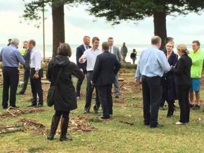
NSW Premier Mike Baird MP inspects the damage (pc: Tom Fitzgerald)
Once again the east coast has experienced the impacts of an east coast low which swept down from south east Queensland last weekend along the NSW coast and then generated extensive flooding in northern Tasmania. There was much damage to property and loss of life. It was fast moving, very energetic and in some respects unusual especially with the large waves coming from the northeast.
I have memories of coastal storms going back to 1946! That summer a mighty hailstorm hit Sydney blasted out the windows of the new high school in Dover Heights. In 1950 we had a series of major storms that eroded beaches. Years later I was shown its impact on the beach at Boat Harbour near Anna Bay by the late Peter McKenzie. He pointed to the location of the 1950 erosion scarp. I have used this as benchmark noting that erosion had not reached this position in subsequent events highlighting the importance of direction of storm waves.
Major clusters of storms in 1967 and 1974-78 had dramatic effects along great lengths of the coast. Most embayments experienced loss of incipient foredunes and erosion back into the established shrub and tree covered dunes along with localised overtopping and washovers. The two east coast lows of 1974 are now regarded as the storms of record. Damage outside and inside harbours was extensive as documented in a number of studies. More recent storms, such as the Pasha Bulk storm of 2007, have had significant but more localised impacts. Monitoring of beach profiles since the 70s by Andy Short and Roger McLean and others provide information on the changes to beach/dune morphology with such events, and work by Angus Gordon and colleagues have documented the loss of sand from beaches during the events and post-storm recovery.
When I reflect on past coastal storms, I have to go back to the paper of E.C. Andrews in 1916 published in the Proceedings of the Royal Society of NSW. This is a must read in my view for those interested in coastal change in NSW. He focussed on the impacts of large wave events inside Botany Bay at Lady Robinsons Beach. He was able to get information back to the tragic Dunbar storm of 1857 and trace subsequent impacts from storms in 1876, 1889 and 1912. He observed the 1912 event on this beach and showed photos indicating scarp position of this and previous bigger storms plus post-storm recovery. There must have been major surge, set-up and run-up processes operating in Botany Bay to produce these features on this east facing beach and foredune. In 1974, refracted waves destroyed the Paragon Café at La Perouse and damaged the new Banksmeadow revetment so we have some idea of what Andrews may have witnessed.
 Sydney’s Storms June 2016 (pc: Tom Fitzgerald)
Last weekend was dramatic in many ways. Damage to property at Collaroy-Narrabeen has been well covered in the media. Ron Cox provided a very good summary in his op ed in the Sydney Morning Herald on Wednesday ( 8th June). Documentation of beach change by Ian Turner and his WRL team is an important contribution to our understanding of the processes and impacts in this tertiary sediment compartment. I also note the good work of Angus Gordon in advising local council and land owners of risks and future requirements in living in such a location. It is a recognisable hot spot and been severely impacted by waves in previous big events. But the impacts this time were selective. Coogee beach was stripped down to the concrete relicts of the old pier demolished in 1934; I did not see these stumps in 1974; whereas the footings of the tunnel-groynes at Bondi demolished in 1942 were seen in 1974 but not this time. Along the coast most incipient foredunes survived although cut back.
One thing I found interesting this time was the seiching behaviour of Sydney Harbour. A high king tide occurred on Sunday and Monday evenings. Waves from the northeast that were pounding the coast at this time produced higher water levels in the Harbour sloshing around at around 1 to 2 minute intervals (we await data from Sydney Ports on details). I have king tide benchmarks at Parsley Bay, Vaucluse. At 9pm I made my way by torchlight to the path to take measurements; alas I didn’t quite make it. Near the net I was hit by a wave as I descended the steps. Even near the beach, well inside the bay, it was too dangerous to go along the path. Water levels fell back and then with a rush surged around my legs and logs started bashing into me—time to take a photo and get out! Next morning one could see the effects. Around Watsons Bay waves had washed small boats and debris above levels locals had never seen before and damaged the paths, road and sailing club. Sand bags were in position to prevent more incursions of water on Monday evening at Doyles Restaurant. All this is very local, yet similar damage was observed elsewhere.
What is important is the need to further understand and communicate the nature of what we just experienced. We must recognise that such coastal storms can produce waves and winds from different directions, they can last longer, they can occur in clusters and on high tides and be associated with flooding from catchments (coincident events) as well as produce dune erosion and surges of water overtopping structures in estuaries as well as on the open coast. It is risky to live in such places, and those who do must inform themselves of the risk they face because such events or worse will occur in future.
Words by Prof Bruce Thom. Please respect Bruce Thom’s thoughts and reference where appropriately: (c) ACS, 2016, posted 10th June 2016, for correspondence about this blog post please email admin@australiancoastalsociety.org.


