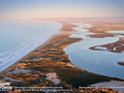
MOUTH OF THE RIVER MURRAY

Our esteemed Vice-President of ACS, Emeritus Professor Nick Harvey, has recently co-authored a paper with Kristine James and Bob Bourman on the flood-tidal delta in the River Murray estuary (Journal of Coastal Research, 2015, 31, 1103-1119). This paper refers to a range of work by these three writers going back to the late 70s on the changes that have occurred at the mouth of our greatest river. Observations of sediment accumulation over many decades are used to tell a very powerful story which they quite significantly refer to in the title of this latest paper as “A Canary in the Cage of River Management”.

Flood tidal sediments are formed by wave/tide deposition inside the mouths of estuaries. They show that such sandy sediments existed in the vicinity of the Murray Mouth prior to the installation of the barrage system in the late 1930s. The mouth is a dynamic coastal inlet involving forces of river flow, micro-tidal exchange, and wave processes moving sand along the barriers that block the majestic Coorong Lagoon. The barrages reduced the tidal prism by 90%. Their study showed that over the 100 year period 1839 to 1938 even with low river flows, the ebb tidal current assisted in maintaining an open river mouth. The flood tidal flats were not vegetated during this time. However, since the barrages have been built the former tidal delta has become a stabilised island, Bird Island, colonised by more than 80 plant species. It took only 5 years for vegetation colonisation to commence indicating permanent alteration to the inlet/river mouth biophysical system. With decline in river flows as well as tidal exchange, longshore sand transport tends to choke the mouth. This leads to periods of mouth closure and the necessity of government intervention to dredge the entrance to ensure as far as possible that Coorong’s water quality is maintained by tidal exchange to a level that according to the Murray Darling Basin Plan (MDBP) 2012 ‘’does not compromise the ecosystem”. At the moment a new dredging program is underway following a recent decline in river flows.
>
It is important to reflect on the initiative of federal and state governments in the development of the MDBP in 2012. The plan was finally accepted after much debate. One section (8, c to e) specifically relates to the environmental objectives of the Lower Lakes and the Coorong. Here the Plan refers to the mouth remaining open at frequencies, for durations and with passing flows, sufficient to enable the conveyance of salt, nutrients and sediment from the MDB to the ocean. In clause 8 (e) reference is made to maintaining levels in the Lower Lakes above 0.4m AHD for 95% of time and 0.0m AHD all of the time. This is said to avoid acidification and allow connection between Lakes Alexandrina and Albert. The Plan thus requires sufficient environmental flow into Lake Alexandrina to meet these targets despite variation in runoff within the catchments of the MDB and extraction for agricultural and urban uses.
In 2008, the Wentworth Group of Concerned Scientists prepared a submission to a Senate Inquiry into provision of water to the Coorong and Lower Lakes (copy available online at Wentworthgroup.org). We had been alerted by David Paton and others to the parlous state of the lakes and Coorong during the drought period then in full swing. During this period lake levels had dropped below 0.0m AHD exposing sand and mud flats. We were aware of changes in the chemistry of lake waters with some parts very alkaline but others reflecting local inputs of acid waters; it seemed that a toxic mess was emerging. We visited Goolwa in February, 2009, to see for ourselves how far the water had receded from the lake shore leaving piers high and dry. I was fascinated by the calcareous mounds of worm casts on the exposed floor reflecting high alkalinity. This state of affairs attracted considerable adverse publicity and community concern. The South Australian Government was spending millions dredging but with no flow from the river and lake level below mean sea level little could be done until a flood came; and it did in 2011 so that the salts, acids and nutrients could be flushed out to sea through an open mouth.

The Wentworth Group and others remain concerned that the MDBP does not adequately address the environmental needs of the Lower Lakes and Coorong. Like most coast and estuary areas impacted adversely by human demands, solutions are not easy to come by. Minster Burke indicated at the time of the release of the MDBP that the mouth would stay open 90% of the time. We argued that this underestimated the power of the sea to bring sand to the entrance and block the inlet as described by James, Bourman and Harvey. It did not take long to close! Extraction of water in the basin for agriculture may continue to get preference over a healthy estuary. The barrages will remain a problem as they age and encounter rising sea levels. Then there is the question of the impact of water availability in the southern half of the Basin under a warmer and drier climate as noted in Schedule 1 of the MDBP. We see in the paper by James, Bourman and Harvey some clear indications of just what has occurred in the past leaving a legacy of difficult issues that must be addressed in the broader context of managing environmental assets in the basin all the way to the mouth; the Lower lakes, the Coorong and the Murray Mouth are clearly canaries in a Basin cage that may suffer more in the future.
– words by Prof Bruce Thom


 Trip to the Southwest Coast of WA