ESTUARINE WATER LEVELS

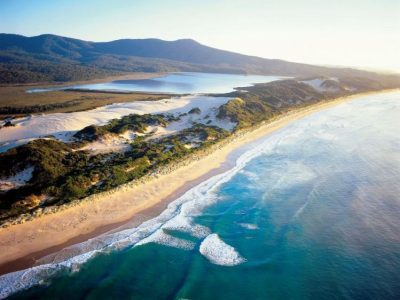
East Gippsland boasts highly significant waterways, with the Gippsland Lakes being the largest estuarine lagoon system in Australia (photo source: East Gippsland Shire Council)
Recent investigations of risk confronting communities around the Australian coast have highlighted estuaries as places where properties and infrastructure are exposed to higher water levels now and in the future. In general, the degree of risk is increased by a factor of ten compared to the open ocean coast, although in some places the risk is clearly higher on the open coast. Thus we must do what we can to understand the dynamics of estuaries.
I use the term water levels rather than simply tidal levels because there are a number of drivers behind higher levels in estuaries not just astronomical tides or higher global sea levels. Water quality is also connected to water levels but I will leave that for another discussion, especially changes in salinity profiles within estuaries.
Eric Bird was the first person to alert me to changing dynamics of estuaries in his pioneering study of the Gippsland Lakes in the late 50s. He showed how the manipulation of entrance conditions was responsible for enhanced flows from the sea leading to changing ecological conditions. Much later I had the opportunity to drill and date a relic flood tidal delta leading into these lakes and showed a massive inlet once provided access to tides for these barrier lagoons. The inlet ceased to exist by around 4000 years ago due to growth of the Outer Barrier. A similar event occurred at The Broadwater, Myall Lakes, reducing that water body to a non-tidal lake.
Also in Victoria, in the 70s, Mark Marsden and his team studied the sedimentary history and estuary dynamics of Western Port. This work demonstrated the role of tidal convergence within an estuary influencing patterns of sedimentation. However, the person who has greatly influenced my understanding of estuary evolution has been Peter Roy. Both Roy and Marsden demonstrated the progressive growth of flood tide deltas as sediment sinks since sea level reached its present position 6000-7000 years ago, a factor that has played a role in determining the water levels in our estuaries over geologic time.
Peter Roy developed a conceptual model of estuary evolution. He was the lead author of a paper in 2001 in Estuarine, Coastal and Shelf Science, 2001, vol. 53, which provides an extensive summary of works on the structure and function of south-east Australian estuaries, their geology, water quality and ecology. His model has been widely adopted by estuary scientists in Australia and overseas. In his various papers, Peter has distinguished a range of estuary types each with distinctive water/tidal level ranges and shown how they have evolved in different settings during the Holocene. The main types are: drowned river valley; barrier estuary (with a mostly open entrance and wave dominated); mature riverine estuary behind a sand barrier; and the wave-dominated saline coastal lagoon, sometimes referred to as ICOLLs. Typically, drowned valleys experience an ocean tidal range whereas the other types have experienced over time modifications to the astronomical tidal range. For instance, ICOLLs have no tides when closed to the sea but when the active beach berm is breached then tidal influence occurs although attenuated to some degree across the shallow flood tide delta. Attenuation is also common with barrier estuaries so that although open to the sea the tidal range and hence water levels are reduced in such locations. A good example is Lake Macquarie. Roy has indicated that for the mature riverine estuary where the proto-lagoon has been infilled by mostly river sediment, the tidal range may switch from a period of attenuation when the lagoon existed to a higher range confined to river channels.
Recent work has shown the general value of this model, but there are complications which I will just touch on. One complication arises when decisions are made to modify (or train) entrances, as noted above for Gippsland, but in many other places including Peel-Harvey in WA. Water levels may increase as a result of dredging the channels. Tidal amplification can also occur in some estuaries and one issue is whether changes in the depth of water over the flood tidal delta will have the effect of raising tidal planes. But that will depend on feedback effects associated with recession of beaches and dunes leading to these deltas becoming potentially shallower as sand is moved into flood tidal delta sinks. If this occurs there would be more frictional attenuation of water levels and a relatively lower not higher tidal range in some estuaries; see why it is complicated! I will let the modellers work on the different scenarios that each estuary may present.
We must recognise that at different time scales there are a range of forces that influence water levels in our estuaries. Levels in Sydney Harbour are not significantly affected by river discharge, but those in Brisbane and Newcastle, and along the great coastal waterways of central and north Queensland certainly are. Angus Gordon informs me of periods of higher water levels in lagoons such as Narrabeen during extended periods of elevated water level in the ocean due to slow moving storms. The ocean also forces water into lakes and lagoons raising their water levels during the passage of a coastal trapped wave. This pumping effect leads to lake levels being well above the normal tide range—an effect which may not be so apparent on the open coast. This is another reason for local flooding of low-lying properties and infrastructure. Then there are ”coincident events” when storm surge, wave setup, wind waves and river floods all combine with high spring tides to raise havoc, a problem of low probability but one that cannot be discounted now and into the future.
– words by Prof. Bruce Thom


 Our response to the draft regional coastal plans in Victoria